Look at the diagram of the compass rose. Use it to answer questions 1 – 3.
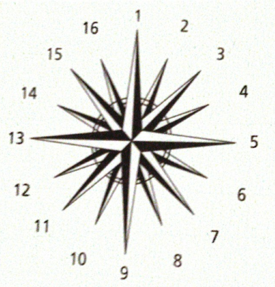
1. Points 5 and 13 are of what type?
a. cardinal points b. intermediate points c. intercardinal points d. secondary intercardinal points
2. If I am standing at point 11, where am I located?
a. SW b. SSW c. W d. WSW
3. A group of Jamaican fishermen left the island on 1 December. Sailing easterly they landed on the shores of our nearest neighbour to the east 12 hours later. On which island did they land?
a. Cuba b. The Cayman Islands c. Haiti d. Antigua
4. Which of the following is correct about lines of latitude?
a. They are parallel lines. b. They are all great circles.
c. They include the Prime Meridian. d. They passed through the North and South Poles.
5. Which of the following does NOT correctly describe the Prime Meridian?
a. It measures 0°. b. It is part of a great circle. c. It passes through Greenwich, London. d. It divides the Earth into northern and southern hemispheres.
6. Which is an example of a low area of land?
a. Island b. Plain c. Hill d. Plateau
7. A _____________________ is a low land between hills.
a. plain b. mountain c. hill d. valley
8. Which best describes a mountain?
a. A landform that rises high and has slopes. b. A landform that is flat at the top.
c. A piece of land between hills. d. A piece of land that is very flat.
9. How are mountains and hills similar?
a. Both are areas of flat land b. Both have pointed tops
c. Both are raised areas of land d. Both are lower than plateaus
Examine the map below carefully then use it to answer the following questions

Choose the correct answer for each question below.
Four sailors travelled from Jamaica in different directions. Mark sailed south east , Ben sailed north east, Jim sailed south west and Jerry east north east.
10. Who would most likely reach Aruba ?
a. Mark b. Ben c. Jim d. Jerry
11. Jamaica nearest neighbor is
a. Haiti b. Cuba c. Puerto Rico d. Barbados
12. Which statement is false ?
a. Jamaica is located to the south of the bahamas b. Puerto Rico is to the east of jamaica.
c. Belize is to the south-south-east of jamaica.. d. Trinidad is south-east of jamaica.
13. Which of the following is the correct absolute location of jamaica?
a. 18° North and 77°West b.South of Cuba c. 77° West and 18°North d. In the caribbean region
14. Identify the set of countries through which 75o W line of longitude passes.
a. The Bahamas, Haiti, Cuba b. Cuba, Panama, Haiti c. The Bahamas, Cuba , Colombia
d. Colombia, Dominican Republic, Aruba
15. Which line of latitude would definitely pass through Guyana, Venezuela and Colombia?
a. 6°N b.10°N c. 9°N d. 12°N
16. Who were the first Europeans to come to Jamaica?
a. Portuguese b. British c. French d. Spanish
17. Who introduced slavery in the Caribbean?
a. English b. French c. Spanish d. British
18. Why were the Africans brought to work as slaves on the sugar plantation?
a. They were the cheapest to buy. .b. They were easier to capture.
c. Ameridian slavery was abolished in the Caribbean.
d. After many Ameridians died there was a great demand for African slave labour.
19. Caribbean ancestors came from all the following EXCEPT:
a. Asia b. Africa c. North d. North America
13. Which group shows the correct order in which the various groups came to the region?
a. Spanish, British, Africans, Indians b. Spanish, Africans, British, Indians
c. ndians, Africans, British, Spanish d. British, Spanish, Africans, Indians
Look carefully at the images of landforms below, the label each correctly.
Mountains valley plain plateaus


Read each statement carefully then match the word on the left to its correct meaning on the right.
Topsoil The natural physical feature of the earth’s surface. Erosion Tiny pieces of rocks or gravel broken down by the process of weathering and moved to another location. Lowlands The upper rich, outermost layer of where the most nutrients for plants are found. Deposition an area of high or mountainous land. Landforms The wearing or washing away of something by wind, water or natural agents. Highlands The natural force that attracts objects to each other. Gravity an area of low, flat land |
Complete the compass rose by inserting the sixteen compass points. Use CAPITAL letters.

Use the words in the rectangles to label the diagrams below correctly.
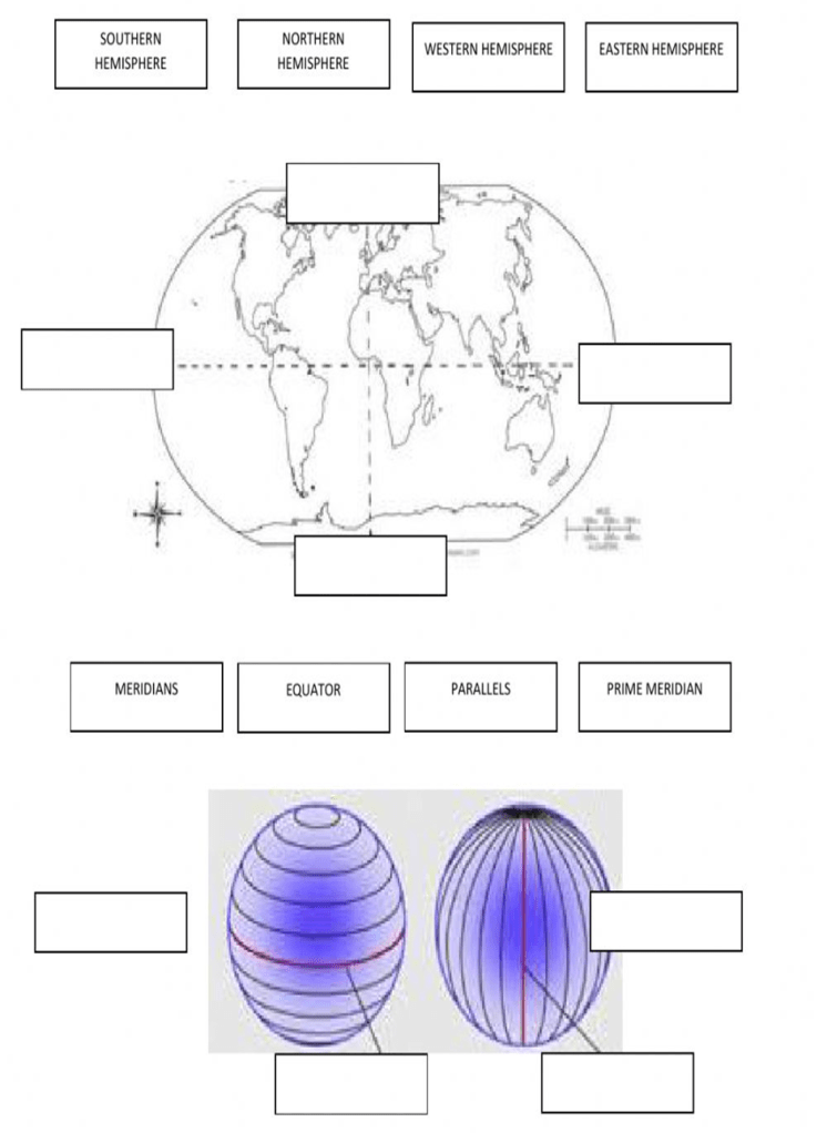
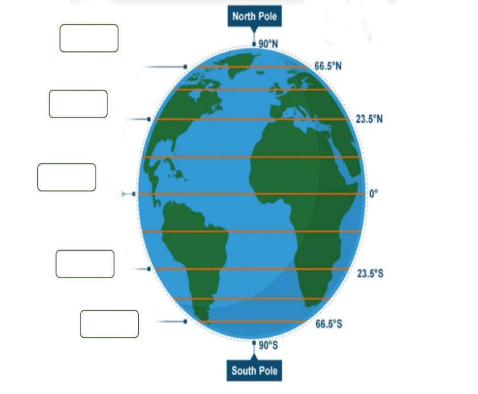
Label the diagram below, using the correct lines of latitude in bold.
Arctic Circle, Antarctic Circle, Equator, Tropic of Cancer, Tropic of Capricorn
The diagram below shows the structure of the Technical Services Department of St. Ann Municipal Corporation. Use the chart below to answer the questions that follow:
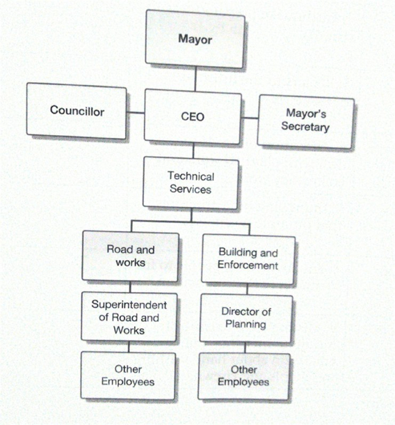
a.) Who is at the head of the municipal corporation? _________________________________________
b.) Who does the Director of Planning report to? ______________________________________
c.) The person who heads the municipal corporation in the absence of the head person. _________
Section C
Base on your understanding, explain each of the following terms:
- Weathering
- Erosion
- Deposition
Give examples of each of the following:
- Highlands
- Lowlands
Name 3 types of rocks that can be found here in Jamaica. Give a brief description and say where each can be found.
What are three negative effects of erosion and deposition?
List and explain 3 human activities that can contribute to erosion and deposition.
What is the actual distance on ground for each of the following, if the scale on a map is 1 cm = 10km.
a. 150 cm b. 1.5 cm c. 305 cm d. 4.5 cm
Using a scale of 1 cm to 100km, calculate the distance on map for each of the following.
a. 250 km b. 6025 km
Write a letter to your friend telling him/her about the parish in which you live and go to school.
Be sure to include:
- the county,
- A brief explanation of municipal corporation,
- Organizational chart of a municipal corporation
Please see other End of year exams for June 2023:
Grade 5 – Math End of Year Exam – June 2023
Grade 5 – Science End of Year Exam – June 2023
Grade 6 – Social Studies End of Year Exam – June 2023

7 thoughts on “Grade 5 – Social Studies End of Year Exam – June 2023”